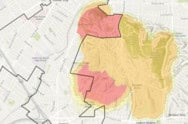
The Office of the State Fire Marshal has released the 2025 Recommended Fire Hazard Severity Zone Maps for Local Responsibility Areas, including Culver City.
Key Highlights
The 2025 FHSZ updates are based on fuel conditions, weather patterns, terrain, and fire behavior modeling.
Zones are categorized as having Moderate, High, or Very High wildfire hazard potential.
The previous LRA maps, last updated by the OSFM in 2007, only designated Very High fire hazard zones.
Culver City Fire Department is recommending maintaining the existing Very High FHSZ boundaries, primarily affecting the Blair Hills neighborhood, and adopting the new High and Moderate FHSZs.
Local governments are required to adopt OSFM-recommended maps (with or without modifications) within 120 days.
What This Means for Property Owners If your property falls within a High or Very High FHSZ, you may be subject to:
Defensible space requirements (100 feet around structures in Very High zones)
Home hardening standards under Wildland-Urban Interface (WUI) codes
Disclosure of FHSZ designation when selling property
View the Maps
City of Culver City

